Earthquakes, tsunamis and plate tectonics

Friday, January 7, 2005, Chandigarh, India
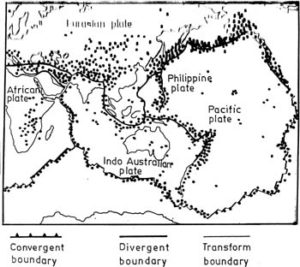
GEOLOGISTS define an earthquake as the shaking or trembling caused by the sudden release of energy, usually as a result of faulting, which involves displacement of rocks along fractures. Earthquakes indicate that the earth is an internally active planet. Most earthquakes take place at well-defined zones at transform, divergent and convergent plate boundaries. There is an interesting relationship between earthquakes and plate boundaries (fig. 1)
About 80 per cent earthquakes occur within the circum-Pacific belt, 8 per cent within the Mediterranean-Asiatic belt and the remaining 5 per cent within plate interiors or along oceanic spreading ridges. Most of the earthquakes result from convergence plate boundaries. The circum-Pacific belt is well known for both its volcanic activity and its earthquakes. About 60 per cent of all volcanic eruptions and 80 per cent of all energy released by earthquakes take place in this belt, that is why it is known as the “Ring of Fire”, alluding to a large number of volcanoes.

The amount of damage and people’s reaction to an earthquake are used to determine an earthquake’s intensity according to the modified Marcelli intensity scale. The Richter magnitude scale and the Marcelli intensity scale are used to express the amount of energy released during the earthquake.
Great hazards are associated with earthquakes such as ground shaking, tsunamis, fire and ground motion.
Tsunamis, a Japanese term meaning “harbour wave”, are in fact seismic waves. They are destructive sea waves generated when a large amount of energy is rapidly released in the body of water. Many result from submarine earthquakes, volcanoes at sea or submarine landslides. Tsunamis have a long wavelength and travel across the open sea at high speed. As tsunamis approach the shore, their wavelengths decrease, and their wave height increase. Therefore, tsunamis can be formidable agents of destruction along shore lines.
Once a tsunami is generated it can travel across the entire ocean and cause destruction far away from its source. In open sea, tsunami travel at several hundred kilometres per hour and commonly go unnoticed as they pass beneath the ships, because they are usually less than one metre high, and the distance between wave crest is typically hundred of kilometres. When they enter shallow water, the wave slows down and water piles up to height anywhere from a metre to 15 to 30 metres. They exert an enormous force against the shore and can inflict serious damage and great loss to life.
Tsunamis differ from wind-produced ocean waves in that energy is transmitted to the waterfront from a sea floor disturbance, so that the entire ocean depth of water participates in the wave motion.
Tsunami Early Warning System: On April 1, 1946 a tsunami originated in the Aleutian trench off the island of Unimak hit Hawaii. Moving at an average speed of 760 km per hour, the tsunamis reached the Hawaiian islands, 3200 km away in less than five hours. Because the wavelength was 150 km, the wave crest arrived about 15 minutes apart.
As the waves approached the island, their height increased to at least 17 metres and thus produced an extremely destructive surf which swept inland and demolished houses, trees and almost everything in its path. Following this tragedy, US Coast and Geodetic Survey established a Tsunami Early Warning System in Honolulu. The system consists of seismographs and instruments that can detect earthquake-generated waves.
Whenever a strong earthquake occurs anywhere in Pacific basin, its location is determined and instruments checked to see if tsunami has been generated. If it has, a warning is sent out to evacuate people from low-lying areas that may be affected. Nevertheless, tsunamis remain a threat to people in coastal areas, especially around the pacific ocean.
One of the nature’s warning signs of approaching tsunami is that some are preceded by a sudden withdrawal of the sea from a coastal region. In fact, the sea might withdraw so far that it cannot be seen and the sea floor is laid bare over a huge area.
A tsunami in about 1390 BC, coupled with the volcanic eruption that caused it, may have contributed to the demise of the Minoan civilisation on Crete.
The writer is Professor, Geology Department, Panjab University.
